PROJECTS
The Green Boulevard Vision
Route 51, A Century of Disinvestment…
Over one hundred years ago, landscape architect Frederick Law Olmsted Jr. envisioned the Saw Mill Run stream corridor as a “green boulevard” of open space to protect against flooding and to serve as a valuable public asset for the Pittsburgh region. In his vision, the stream corridor could be a lush landscape traversed by Saw Mill Run and enjoyed by the region’s residents as an escape from city life. Unfortunately, this once verdant stream corridor is now plagued by frequent flooding, daily traffic congestion, and haphazard development patterns.
In 2022, with funding from the Pennsylvania Department of Conservation and Natural Resources and the Richard King Mellon Foundation, Watersheds of South Pittsburgh embarked on a 2-year process to develop a Master Site Development Plan (MSDP) for the Saw Mill Run corridor.
This project, facilitated by Environmental Planning and Design, included the following partners:
City of Pittsburgh Department of Planning,
Pittsburgh Water and Sewer Authority
Allegheny County
PennDOT
Riverlife
Pittsburgh Regional Transit
State Representative Jessica Benham’s office.
And many more community members.
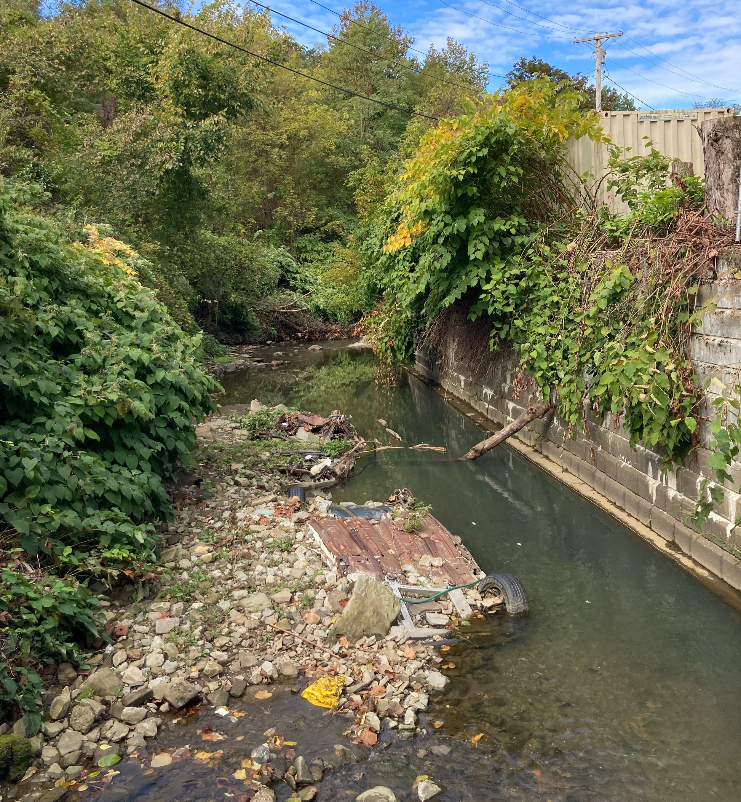
Two vehicles upside-down and embedded in Saw Mill Run behind Red White & Blue Thrift Store.
Urban Stream Syndrome describes the impacts of impervious surfaces and intense land development on streams. It is usually characterized by increased nutrients and contaminants in the water, sudden or “flashy” changes in water level, modified channel shape or structure, and reduced biodiversity.
The Sawmill Run valley, from the West End to Fairhaven and possibly beyond, offers a park and parkway opportunity which should not be neglected until commercial development becomes a serious stumbling block to its realization. It is an interesting valley of varying width and form, enclosed by high, steep banks, occasionally wooded; in some parts it is wide enough only for a drive, while in others large, flat meadows make ideal places for play. And Sawmill Run itself, when it is no longer used as an open sewer, will be an additional element of park value. Surrounded as it is by land accessible to the city and reasonably adapted to residential use, this valley seems an unusual opportunity for effective park service. In taking it for park use, Shalerville and the Bell Tavern settlement would, of course, be excepted; otherwise, the holdings should be continuous from Temperanceville to Fairhaven, and such scattered buildings as would in any way impair the value of the park should eventually be removed. A boulevard thoroughfare should extend the length of the valley, serving not only as a cross-town connection between important radial thoroughfares, but as a link in a circumferential parkway system.
— Frederick Law Olmstead Jr., 1910
Our Vision for a Greener Future
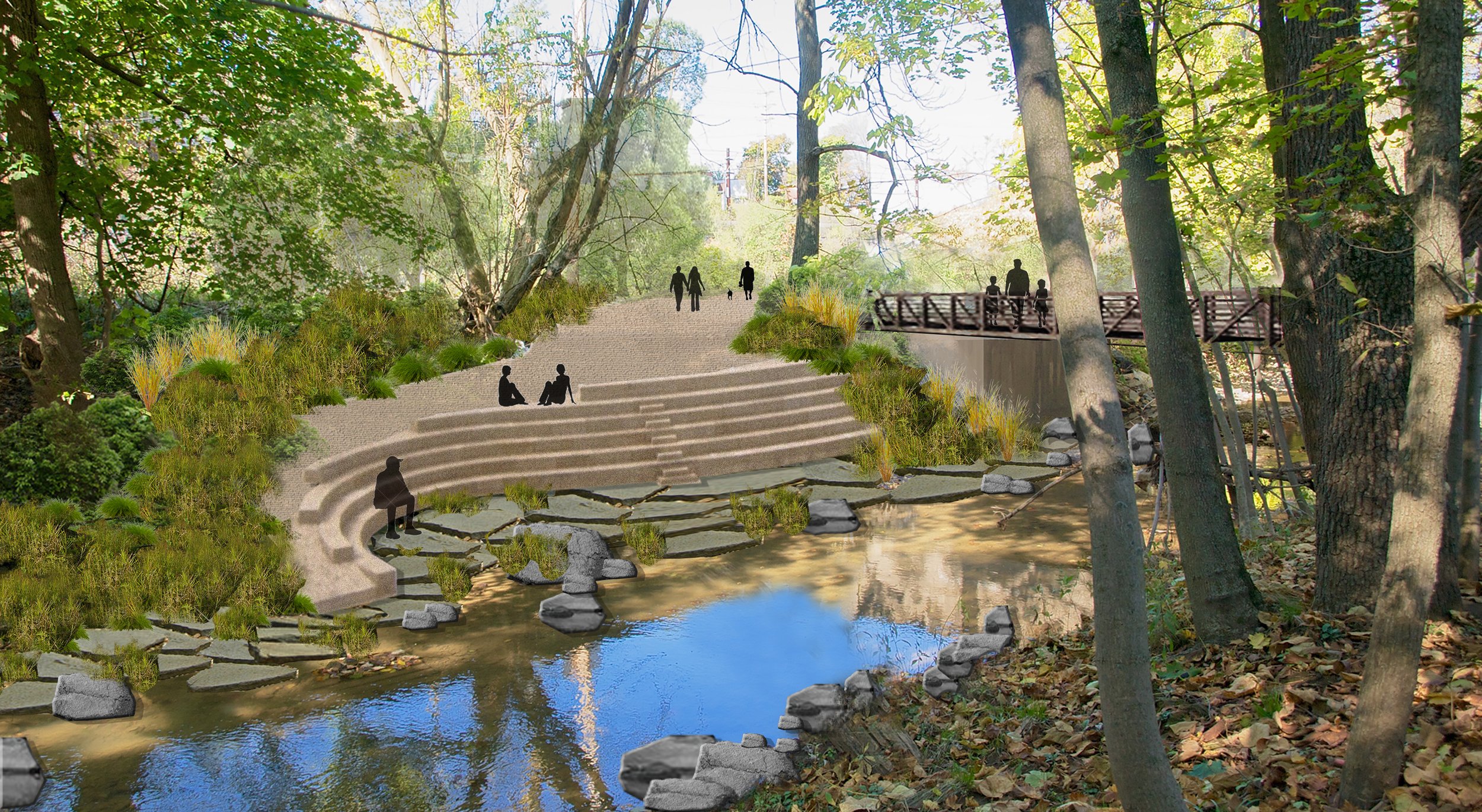
Our challenge is to shift the current perception of the stream as a deterrent to transportation and development into one that embraces the stream as a regional asset. We believe that if more people could see the stream in this new light – as a catalyst for change - we could transform this blighted corridor into a linear park that connects the southern neighborhoods to downtown Pittsburgh’s economic and cultural assets. While it is unlikely that Olmsted Jr.’s vision will ever be fully realized, the Saw Mill Run Master Site Development Plan aims to reinvigorate his concept for the corridor in the context of today’s challenges and opportunities.
Most people find it difficult to envision something that they cannot see. Imagining a different future for their neighborhoods, parks, greenspaces, or main streets can be challenging without strong visual examples. Real transformation of the Saw Mill Run Corridor will result from updates to policies and enforcement of regulations. These changes must be supported by improvements that benefit the appearance, safety, resilience, and identity of the Corridor for those who live near it, work in it, or drive through it on a daily basis.
The Study Corridor
The boundaries of the study area, called the “Study Corridor”, have been delineated to maintain a clear focus on Saw Mill Run and Route 51 (also known as Saw Mill Run Boulevard). While the primary focus of the MSDP includes the parcels immediately adjacent to the stream and the road, the wider-reaching Study Corridor has been identified to include considerations for uphill and upstream influences surrounding Saw Mill Run. The Study Corridor reaches from the West End Bridge to the intersection of Route 51 with Route 88 (Library Road), from the stream bottom to the nearest ridgetop on either side of its banks.
Analyses of the land within the Study Corridor revealed “situational typologies”, which are land areas or parcels that share similar contextual and environmental conditions such as stream constrictions, accessibility, topography, position in the watershed, and ownership type. Each of the typologies is represented by one of the six Design Focus Areas.
From north to south, the Design Focus Areas include Wabash Park, Seldom Seen Greenway, the stream channel nicknamed The “Bathtub” south of Woodruff Street, the area surrounding Red, White, and Blue Thrift store, Ansonia Place, and the area surrounding Accamando Center.
A map of the design focus areas within the study corridor.
The Plan Recommendations
Policies - Zoning changes to promote environmentally-mindful Land Use and Floodplain regulations.
Coordination - Creating a Task Force consisting of all agencies at work within the Corridor to further planning efforts.
Stakeholder Engagement - Develop and support local neighborhood leaders as advocates for change that benefits the community.
Physical improvements to the six Design Focus Areas.
The Design Focus Areas and the Corridor-wide recommendations aim to elevate the perception and raise awareness of the Corridor, while balancing the needs of property owners with the area’s natural capacity. Establishing routine collaborations and leveraging related improvements are essential steps to implementing the recommendations of the plan. Through these changes, the Saw Mill Run Corridor can become a Green Boulevard — a safe and enjoyable space for those who use it to live, work, and commute for generations to come.
Conceptual design of Ansonia Place by Carla Luckhart.
A look at what could be…
A conceptual design of a Green Saw Mill Run Boulevard by Carla Luckhart.
The Design Focus Areas

Accomando Center

Seldom Seen Greenway

Wabash Park

Red White and Blue Thrift Store

Ansonia Place

The Bathtub
MASTER SITE DEVELOPMENT PLAN
Today, challenges like frequent flooding and traffic congestion mark the corridor, but the Saw Mill Run Green Boulevard concept integrates contemporary solutions with Olmsted's vision. Our Master Site Development Plan seeks to balance environmental, social, and economic factors to revitalize the Saw Mill Run Corridor, converting under-utilized areas into vibrant, naturalized spaces that enhance community life and natural habitats.
“A Task Force to make the Saw Mill Run Corridor better, safer, more resilient, more attractive, and more vibrant.”
Before pursuing plan implementation, the input from stakeholder interviews, the Advisory Committee, and the Public Workshop underscored the need for improved collaboration between the many agencies that work in the Corridor. The process of developing the MSDP and speaking with stakeholders unveiled aspects of management that do not fall clearly into one department’s responsibility or mission.
As a result, some tasks (such as the removal of a car that remains in the bottom of the stream) are difficult to initiate and see to completion because the responsibility can be passed between many different entities without landing on a clear solution. For a property owner attempting to resolve an issue, the task only becomes more complicated.
Now, Watersheds of South Pittsburgh is seeking input and participation in developing a cohort of community leaders to promote and facilitate implementation of the projects identified in the plan. This working group or “Task Force” will regularly convene and pursue the goals and implementation of the MSDP.
Visit the Saw Mill Run Task Force page for more updates!
Roles for the Saw Mill Run TaskforceTo help increase community participation, visit the City of Pittsburgh’s Engage Page and please complete the survey below. The survey should take approximately 5 minutes.


